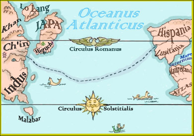
From Go West Young Warrior, part 1, of the #Xena Virtual Season, here’s a close-up of King Gabriel’s map of the Atlantic ocean, based on the best data available to him. When designing this map, I imagined that he commissioned Hispanian cartographers, which is to say, Romans, since Rome is ascendant at this point of in the show. Therefore the most important latitude is Circulus Romanus (a name I made up) which is the latitude that runs through the city of Rome.
I also made up the Roman name for the Tropic of Cancer, Circulus Soltitialis, which was pointless, as it turned out, because they also called it the Tropic of Cancer! I chose map names like “Khan” to refer to the original pitch for #Xena, as a hero pursued by Khan the warlord. I included Higuchi, since Xena had been there, & it was the easternmost city they knew of.
Lo Lang is imo the Korean equivalent of Japa (for Japan) & Ch’in, (for China). I was trying to plant the idea that #Xena might go there in a possible future episode. Of course, the show never used naps like this. Anything on a scroll was usually abstract in nature. You didn’t see readable words or recognizable maps.
The only time I recall an accurate map was when #Xena traveled to Ch’in in The Debt, & that was an animated insert, not a physical prop Xena was reading.
So you may ask: why is King Gabriel of all people in this episode? I have a theory, that we’ll learn about in part 2.